
C.M. Madduma Bandara**

Some Past Attempts: Since [securing] National Independence in 1948, there [have been] three Constitutions (including the present) that governed this Country. The First was the Soulbury (/Jennings) Constitution that lasted for less than 15 years, and then the Republican Constitution of 1972 during the regime of Prime Minister Sirimao Bandaranaike that had a similar life span until it was superseded by the present Constitution enacted during the early regime of President JR JayEwardena. The last one, despite numerous amendments from time to time, [has been in force for] nearly 40 years, despite the fact that it was referred to as “Bahubhhootha Vyawasthawa” (nonsensical or mad constitution) by President Chandrika Bandaranaike. However, the number of amendments effected over the years indicated that all was not well during its life span. It also perhaps reflects a general belief among the past politicians that the problem is with the dancing floor rather than with the dancer!.
Therefore, several attempts [have been] made to replace the prevailing Constitution during the last 25 years, with several Committees (at least three major ones, in 1997, 2006 and 2016) appointed by different Heads of State, that were eventually abandoned halfway due to changing circumstances and political contexts. One common feature has been the fact] that, in all these attempts the ‘Unit of Devolution’ was a significant bone of contention. The present Committee on Constitutional Reforms, despite its enlightened membership, may have the same fate, if it fails to make swift progress and take action to prevent its demise amidst ensuing political storms where often the laws of the jungle may reign.
Given the past records of political performance, which were often dominated by colonial or foreign modes of thought, it may be necessary to make fresh attempts in the present context of a predominantly Sinhalese Buddhist Government, develop a Constitution borne from the soil and nurtured by the majority of people in this Country. It is pertinent to mention that, all democratically elected governments since Independence, have signally failed even to restore the old name of the Country, or reintroduce the Traditional Flag which was brought down publicly by the British Colonial Rulers. As some writers perceptively observed, the legacy of the colonial rule in its manifold form, has crippled our minds and abilities of thinking ‘out of the box’.
In the context of regional governance, successive governments have also failed to abandon the old colonial structure of 9 Provinces. It is against the above backdrop that, one has to consider the current positive thinking of the Prime Minister, on reintroducing the old Sinhalese regional Trinity of Ruhunu, Maya and Pihiti.
Current Developments
The silent discontent prevailing at present among the general public with regard to Provincial Governance, which is generally considered as a “white elephant”, and how the stimulus this state of affairs provides, to go forward towards fresh and innovative thinking, is indeed fascinating and encouraging. In this context, some public statements attributed recently to the Prime Minister and the Minister in-charge of Provincial Councils are of great importance to the future of this Country. The practical thinking reflected by them will be greatly appreciated by a large segment of the general public.
History of Nine Provinces
The nine existing Provinces to which attempts have been made to devolve powers of governance were created almost 130 years ago (1889) during colonial rule for their own benefit. This had been reiterated in our writings during the last three decades. We also stressed that, it is necessary for Sri Lanka, to develop a system of its own regions befitting its natural endowments — [a system that] at the same time that, ensures long-term stability and national harmony, while stimulating the processes of conservation and development. In this context it is needless to mention that, the statements made by the Prime Minister, particularly the reduction of the number of Province to 3 (i.e. one third of the present number) based on the ancient Divisions of Ruhunu, Maya and Pihiti is timely, practical and thought – provoking.
A former Leader of the opposition, Hon. R. Sambandan, addressing the Parliament in January 2015, observed that for a small country like Sri Lanka 3 or 4 Provinces would be sufficient. Despite the fact that he may have had different thoughts about re-demarcating the boundaries of such regions, there has been some confluence of thought regarding the need for a smaller number of Provinces. The Public Consultation Committee for Constitutional Reform appointed by the last Government (Lal Wijenayake Committee), shared similar sentiments and proposed in their Report that, Sri Lanka may best be divided into 5 major regions based on river basins, while ensuring that each province will encompass a share of the coastal sea board allowing direct access to the oceanic resources. While these developments in general, signified the building of some shared collective thinking, it is possible to argue that the prevailing stable political environment is capable of converting such thoughts to reality through practical action.
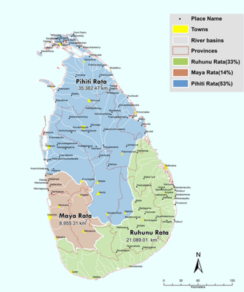
This paper attempts to demonstrate the practicablity of re-establishing a threefold regional structure based on the ancient Divisions of Ruhunu, Maya and Pihiti, which is likely to bestow numerous advantages and long-term stability to the Country. It also indicates the value of lessons learned from history and the fact that it is a realizable proposal within a relatively short period of time. This is demonstrated through a Map of the three ancient regions bounded by natural river basins as adopted in the historical past (See Map).
A table of statistics based on the last Census of 2012, includes the land areas of the each major region, their total populations, and their ethnic compositions. Our earlier proposals that indicated more regional units based of river basins is modified here to suit the public sentiments to have a minimum number of regions, that would minimize the colossal public expenditure now committed to maintain the present 9 Provinces that hardly yielded the desired results.
Some Doubts Raised
In some discussions on the subject, a question was raised as to why [a small country such as our island] needs regionalization at all, while it can be governed from a single Centre? The answer to this lies in the exceptional diversity of the Island, despite its limited land area, as reflected in its climate, land and soils, water, flora and fauna as well as in the human diversity. Its proximity to the Sub-continent of India, and the midway location between the East and West in terms of sea routes, further engendered such diversities while also creating significant security concerns. Therefore, a three-fold regionalization was evolved through some historic logic, and it prevailed in the Island from ancient times. It continued until the dawn of western colonial domination which created a regionalization of a different sort, as foreign invasions were by naval powers who created a system maritime province based mainly on their military capability to expand into the interior. This was the historical reason for the existence of belt-like maritime provinces and land-locked territories up to the present day.
A Cartographic Analysis
The ancient regional Divisions were based on natural river basins. Thus the border between Pihiti Rata and Maya Rata was marked by the Deduru Oya, which also marks the transition from Dry Zone to the Wet Zone. Similarly, the border between Ruhunu Rata and Pihiti Rata was the Mahaweli Basin, while the Bentota Ganga on the South West marked a cultural transition zone as well. The historical boundaries were employed to demarcate the three ancient regions of Ruhunu, Maya and Pihiti on a modern map of the Island. The results yielded were fascinating and challenging. Ruhunu Rata covered and area of about 33% of the land area of the Country, While Pihiti Rata encompassed some 53% of the Territory. The Maya Rata on the other hand proved to be much smaller with a high density of population. It may be mentioned that both Ruhunu Rata and Pihiti Rata encompass extensive conservation zones and National Parks such as Yala and Wilpattu.
With regard to population, Maya Rata has the largest share with about 40% of the total population of the Island. Then the Pihiti Rata has nearly 35%, while the Ruhunu Rata accounted for some 25%. Of the total. In terms of the ethnic composition, Pihiti Rata included some 64% Sinhalese and 36% of the minorities of Tamil, Muslim and other communities. In Ruhunu Rata covering part of the Eastern coastal areas including the major townships of Batticaloa and Ampara, has nearly 75% Sinhala and 25% of all others. In the Maya Rata, a high concentration of Sinhalese accounting for some 84% was found while balance 16% comprised of all other minorities. It may be of interest to note that, in all three Divisions, Sinhalese population exceeded 64% of in all three regions.
These figures were derived from the Census data of 2012, aggregated at the Grama Niladhari Division levels. The interpretation of the results is left to individual readers according to their preferences and inclinations. However, the following positive impacts are discernible.
- The proposal results in only three regions, compared with the present 9 Provinces, and therefore reduces the colossal expenditure now incurred on provincial governance. There will be only three Governors and three Chief Ministers and so on, in place of the present 9 and their provincial cabinets.
- Every Region has a sea frontage and there will be no land locked-provinces as in the present set-up created by the colonial rule. Therefore as an Island, each region will have direct access to the riches of seas.
- The use of a neutral criterion like natural river basin watersheds, following the practice of the historical past, may bestow some benefits for more efficient resources management. It will do away with ‘Inter-provincial rivers’ created by the 13th Amendment to the Constitution. Mahaweli waters may be conveyed to the North and East without any hindrance. It may also help in protecting the investments on land and water development that, forms the largest share of all investments since Independence.
- A smaller number of larger regions will make them economically viable units, which have their own earnings, expanded markets and abilities to invest in larger projects.
- New Regions will ensure the integrity and conservation of National Parks, Forest Reserves and other areas of Conservation and mange problems like human elephant conflicts more efficiently.
- It will help in managing natural disasters such as floods and droughts in an era of global climate changes, as natural river basins can be managed more efficiently.
- They can facilitate economic progress without glaring urban biases, between the core and the periphery while containing the depopulation of rural areas due to migration to the Capital City.
On the whole, it is likely that the new regional structure will enhance long term political stability, support economic progress, improve national harmony, conservation of natural endowments of land, water and biota and facilitate more efficient planning to mitigate natural disasters.
**** ****
ADDITIONAL INFORMATION from Professor Madduma Bandara, dated 15 February 2021:
A copy of this article in Sinhala was published in the Divaina Newspaper about 3 months back. ….. Much earlier, my ideas on the need for new provinces were presented at different fora since 1991 and some of them were published. (eg. Survey Institute’s Symposium on Rational Provincial Boundaries in 1991; National Geographic Conference of 1992; as a small pamphlet in the Peradeniya University Lecture series (PULSE); my submissions to the Constitutional Reform Committee (2016, Lal Wijenaike Committee) and at the Organization for Professional Associations on several occasions). You may note that, as reflected in these publications, my main proposal seeks to redefine provincial boundaries based on a neutral criterion (non-ethnic, non-sectarian) like river basin boundaries continued to remain intact. However, sensing the public aspirations to reduce the number of provinces I gradually moved towards the minimum (i.e. three provinces) still anchored on natural river basin boundaries. Hope the above brief explanation would answer at least some of your queries.
AUTHORS’ Appreciative NOTE: In collecting relevant data and in map analyses, the assistance of provided by Dr. Kumudini Kumarihamy, Senior Lecturer, University of Peradeniya, Asela Bandara, GIS Expert at WHO Geneva, and Hiran Thilakaratne and Ranjith Weerasekara of the Disaster Management Centre, Colombo, is gratefully acknowledged and highly appreciated.)
** Dr. Madduma Bandara is an Emeritus Professor, University of Peradeniya …. Bio-data canbe found at https://scholar.google.com/citations?user=NXGaxvoAAAAJ&hl=en AND
EDITORIAL NOTE: I have taken the liberty of smoothenng the phraseology in some spots — [usually identified by square brackets]
COMMENTS as Michael Roberts, 15 February 2021:
A: In my social science experience geography must always be given serious consideration and my friend Maddu’s stress on the river basin system and its importance must be taken into consideration — even though it raises novel and serious problems when set against the various gramasevaka and local divisions and the dependence of our statistical tables on these modalities of existence.
However, the statement that his scheme is based on “the ancient Divisions of Ruhunu, Maya and Pihiti” will immediately raise the hackles of both the local Tamil and Moor (Muslim) communities. Such a perspective and the regional nomenclature raised to the fore smacks of Sinhala chauvinism. This ‘tinge’ could render the scheme into a non-starter.
A FURTHER NOTE, 4 June 2021:
The metropolitan cluster of Greater Colombo is so important in both economic clout and political weight; and its demography includes so many Tamils and Muslims that I advocate a special corpus of representation for this arena.

Wrong map of ruhunu, maya and pihiti.
Pingback: kotmale temple - Travel Safari
Pingback: The Vital Role of the Northern & Eastern Provinces for Sri Lanka NOW | Thuppahi's Blog